Fascinating atlas traces Cork city heritage through the ages
The Irish Historic Towns Atlas of Cork is a gold-mine of information about the city’s long history, reaching back in time to map out the changing landscape, says SARAH GEARTY, cartographic editor of the volume
Fascinating atlas traces Cork city heritage through the ages

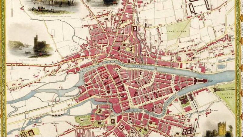
One of the maps in the Irish Historic Towns Atlas, showing Cork in 1851.

A TREASURE trove of detail is contained in a new historical atlas of Cork, which goes on sale this week, and explores the city from its origins to the present day
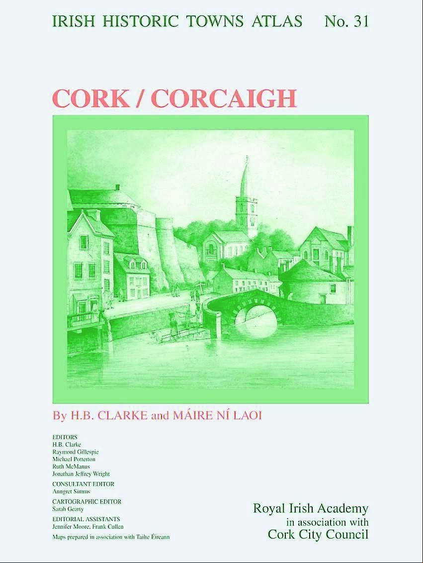
Published by the Royal Irish Academy, The Irish Historic Towns Atlas of Cork is a large and weighty tome, with a cover showing the ‘old St Finbarr’s’ and Elizabeth Fort, illustrating the city’s antiquity.

Within the outer folder is a hefty bound booklet of 204 pages followed by 40 large loose sheets of visual material, including several folded pages. Where to start?

Many will head straight for the loose sheets, which display a whole range of maps, views and photographs of Cork, all with the intention of allowing the reader to follow the topographical story of the city from its origins to the present day.

Some of these are impressive foldouts that were specially commissioned for the Cork atlas.

‘Map 2’ (760 x 900 mm) brings us into the 19th century city. It has been created using the most advanced technology, harnessing very detailed historic Ordnance Survey town plans, depicting in colour each house, yard, garden, public building, street and lane in 1842.

An inset map of Blackpool is included in the top left corner, with the Barracks, Custom House, Union Workhouse (now City General Hospital) and County Gaol (now UCC) marking the extent of coverage from the north-east to the south-west.

The Irish Historic Towns Atlas, no. 31, Cork/Corcaigh.

This map is one of four in the atlas that are produced to a standard scale and style - this means that they may be compared with the other 30 town atlases in the Irish series, and potentially with the 600-ish published for the whole of Europe.

Ireland is one of 19 countries co-operating in the production of such Historic Towns Atlases internationally.

Another large bespoke map in the bundle is ‘Map 5’. Though the same size (and scale) as Map 2, it is very different in content. This time we see 12 centuries of Cork’s history superimposed on the modern street plan.

More than 100 historic sites from St Fin Barre’s monastic foundation (c. 625) up to c. 1750 are listed thematically and plotted along with the early River Lee and its subsidiary channels, including those that have since been built over or diverted.

A highlight for many will be the sequence of 33 sheets that take us on visual tour of the historic city up to 1900, mainly through spectacular reproductions of old maps, the earliest of which dates to 1545 - this is called the ‘Tower map’ as it is a copy of an original sketch that was in the Tower of London and it is the earliest cartographic depiction we have of any Irish town or city.

Though informative, any lack of detail is more than compensated by subsequent maps from the17th century, particularly two ‘bird’s eye’ style depictions of Cork from originals in the Hardiman Collection in Trinity College Dublin, hand drawn and coloured with individual buildings (complete with roofs) and town walls artistically illustrated.

Later, four maps drawn for military purposes allow us to see the shape of the late 17th century city and its emerging suburbs.

Wolfgang Romer’s ‘Map of Cork with new retrenchments, c. 1690’ is particularly special as up until relatively recently, it was unknown to researchers and held in a private collection in the UK until its acquisition by the Boole Library, UCC in 2023.

Nine pages of maps and views are dedicated to 18th-century Cork. Printed maps including the earliest known Irish example by John Carty are reproduced for 1726, 1750, 1759, 1774 and 1789 - the later three by John Rocque, Joseph Connor and Daniel Murphy are on double sheets with an unprecedented quality of detail.

Interspersed are topographical views mainly from the collection of the Crawford Art Gallery, Cork, most notably a fine reproduction of John Butt’s painting of c. 1750. This would be suitable for framing, as would several which follow for the 19th century by William Beauford (1801), Thomas Holt (1832) and John Rapkin (1851) respectively, each in colour, complete with cartouches and ornate titles.

Zooming in to street level, a fascinating plan of what would become Washington Street and surrounding area by the Cork Wide Streets Commissioners from c. 1825 is reproduced from a rich collection in the Cork City and County Archive.

This would have been a working map, hence evidence of wear and tear, but the pleasure is in the level of detail recorded for the leaseholders and their properties prior to the new layout.

Ordnance Survey and Valuation Office manuscript town plans of the era are similarly forensic, and extracts are reproduced, with the six-inch ‘fair plan’ setting the context, in all covering the period 1842-70.

Griffith’s valuation list of 1852 has been plotted to show the distribution of housing from £3 to over £40 in the city.

Further paintings from the Crawford Gallery appear, illustrating the river and quays with sail boats and paddles steamers for 1842 and 1886.

Photographs from collections from Cork Public Museum and the National Library of Ireland show different city streets and perspectives at the turn of the 20th century.

An extract from Goad’s insurance plan of 1897 itemises properties from St Patrick’s Street to Lavitt’s Quay, showing the potential of that source (Cork City Libraries hold a full set).

The final map in the sequence is one produced for the publication that displays in colour different phases of growth from c. 1300 to 1900. At the same scale (1:5000), a vertical aerial photograph from 2017 follows and offers a useful comparison for the present-day cityscape.

For some, the booklet that accompanies the maps and plates will be the starting point. Here you will find a descriptive essay drawing together hundreds of primary and secondary sources on the evolution of the city.

Separately, a gazetteer gives details of more than 13,000 historic sites.

The basis for this is research carried out by the authors Professor Howard Clarke and Máire Ní Laoi over many years.

Irish Historic Towns Atlas, no. 31, Cork/Corcaigh, by H.B. Clarke and Máire Ní Laoi, is published by the Royal Irish Academy in association with Cork City Council and was launched in City Hall on May 14.

It is available to order from ria.ie/cork - or from all good bookshops now.

About the Irish Historic Towns Atlas research programme

Based at the Royal Irish Academy, the Irish Historic Towns Atlas research programme traces the topographical development of towns, cities and suburbs through its atlas and ancillary publications, annual seminars, and special exhibitions.

It is part of a wider international scheme that covers 19 countries.

The Irish programme is considered a leader in the development of digital atlases of this kind.

Read More

Cork man launches book about the band that changed course of Irish music

More in this section

Calling Cork schools and clubs...We want to hear from you for our KidzZone special Calling Cork schools and clubs...We want to hear from you for our KidzZone special
My Weekend: ‘Catching up with friends is such a salve’ My Weekend: ‘Catching up with friends is such a salve’
'Meeting friends and getting chips afterwards is a big part of it': Father and son on joy of sailing 'Meeting friends and getting chips afterwards is a big part of it': Father and son on joy of sailing

Sponsored Content

Digital advertising in focus at Irish Examiner’s Lunch & Learn event  Digital advertising in focus at Irish Examiner’s Lunch & Learn event 
Experience a burst of culture with Cork Midsummer Festival  Experience a burst of culture with Cork Midsummer Festival 
How to get involved in Bike Week 2025 How to get involved in Bike Week 2025
Us Cookie Policy and Conditions

© Examiner Echo Group Limited

Add Echolive.ie to your home screen - easy access to Cork news, views, sport and more